Anyone who has ever witnessed the ferocity of a hurricane, or the terrifying devastation of a tornado knows all too well the destructive ability of Mother Nature. Luckily, when natural disaster threatens the United States, we have an agency responsible for providing warning so that citizens can prepare, take shelter or even evacuate, if necessary.
That agency is a component of the National Oceanic and Atmospheric Administration (NOAA) called the National Weather Service (NWS), and its ability to effectively accomplish its mission really can be the difference between life and death for American citizens.
In June of this year, the National Weather Service Office (NWSO) at Pago Pago, American Samoa signed a contract with SES Space and Defense for a new tool to help them accomplish their very important mission – a highly reliable, low latency link for passing critically important weather information between the NSWO in Pago Pago and the NWS headquarters Office on Ford Island in Honolulu, Hawaii.
This contract with SES Space and Defense was notable for two reasons.
First, the satellite constellation that the NWSO in Pago Pago would be utilizing would not be the company’s GEO constellation. Instead, the satellite constellation carrying information between American Samoa and Hawaii would be the newer O3b MEO constellation of satellites, which promise fiber-like throughputs and lower latency.
Second, the contract signed between the NWSO in Pago Pago and SES Space and Defense was not just for the lease of some satellite capacity, but rather for a complete satellite managed service. This decision to move forward with satellite as a managed service is a revolutionary, innovative step forward for the federal government, since managed services are widely considered the more economical and efficient acquisition model that is the future of the satellite industry.
To learn more about this revolutionary new satellite service being implemented by the NWS, we spoke to Ray Tanabe, the Pacific Region Director at NWS, and Per Pedersen, the Systems Integration Branch Chief at NWS. During our discussion, we asked about the NWSO at Pago Pago’s mission, why it’s so fundamentally important, and the role that the O3b managed satellite services will play in the office accomplishing that mission.
Here is what they had to say:
GovSat Report: What is the mission of NOAA’s National Weather Service Office (NWSO) at Pago Pago, American Samoa? Is there something about this weather station that makes it particularly essential for weather forecasting and prediction?
Ray Tanabe: The mission of Weather Service Office (WSO) Pago Pago is exactly the same as every other NWS office in the United States, to, “Provide weather, water, and climate data, forecasts and warnings for the protection of life and property and enhancement of the national economy.”
WSO Pago Pago has the distinction of being the only NWS office in the southern hemisphere and serves a population of approximately 55,000 people spread out over five rugged, volcanic islands and two coral atolls. One these seven islands, Rose Atoll, is a Marine National Monument.
Primary threats to American Samoa include hazardous sea conditions around the islands, tropical cyclones, heavy rainfall, and tsunamis. The relative isolation of these islands, complex geography, lack of a weather radar, makes the forecasts and warnings issued by WSO Pago Pago very important.
GovSat Report: Why is COMSATCOM essential for connecting this station? Is Pago Pago’s geography and location particularly challenging for the installation of terrestrial networks? What makes satellite – and specifically COMSATCOM – so important for connectivity here?
Per Pedersen: Present day weather forecasting and prediction is very much data driven. Predictive computer models, satellite and radar data from multiple sources and observational data form the basis for the production of forecasts and warnings. It is essential that WSO Pago Pago have reliable network capability to access this data.
The remote location in American Samoa is a challenge as there are limited terrestrial network options.
In the process of upgrading the network communications for WSO Pago Pago, several highly-reliable, high-bandwidth solutions were considered, and the MEO satellite based solution from O3b/SES Space and Defense was found to be the best and most cost-effective for our requirements.
GovSat Report: O3b operates a MEO constellation that has been touted as capable of delivering fiber-like connectivity via satellite. Why was a high-bandwidth, low-latency MEO constellation necessary for this weather station? What kind of data will be transmitted? Why was a traditional GEO constellation not chosen for its data needs?
Per Pedersen: The low-latency MEO solution from O3b/SES Space and Defense provides the scalability and flexibility we need. The large data sets we use require high-capacity data transmission capability and the low latency provides the technological versatility that will allow us to tailor this solution to anticipated future needs, comparable to what we would be able to do using a fiber-based solution.
GovSat Report: Although many have tabbed managed services as the future of COMSATCOM, we haven’t seen many government agencies move in that direction yet. Why did NWS decide to pursue a managed service with SES Space and Defense and O3b? What benefits will a managed service solution deliver over the traditional leasing of capacity?
Per Pedersen: Our forecasting and warning operations run 24x7x365 and we support our operations accordingly. The availability and expertise provided under this contract allow us to cost-efficiently support our operations without having to acquire dedicated, in-house expertise required for this specialized technology.
GovSat Report: How far along is the implementation of this managed service at Pago Pago? Is it active now? Is it coming online soon? If it’s already online, what have initial responses been to the service?
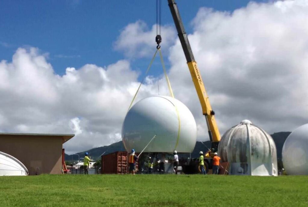
Per Pedersen: The antennas and protective radomes were installed in late May of this year, and after initial testing and reliability verification the system was declared operational. The service has been operating fully successfully since then.
For additional information about the O3b MEO satellite constellation and the benefits it can deliver to the federal government, click on the following resources: